SAR Fundamentals/Navigation/Map/Topography
From PCSAR
(→Time Plan) |
(→Time Plan) |
||
| (10 intermediate revisions not shown.) | |||
| Line 26: | Line 26: | ||
== Time Plan == | == Time Plan == | ||
| - | Total Time: | + | Total Time: 45 minutes |
{{lesson slides start}} | {{lesson slides start}} | ||
| Line 57: | Line 57: | ||
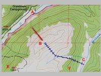
* find highest, lowest spot on map | * find highest, lowest spot on map | ||
{{lesson slide||}} | {{lesson slide||}} | ||
| - | * steepness of slope. find steepest, | + | [[Image:Members:2012-02-14 23 03 39u-scan.pdf|page=14|right|200px]] |
| + | [[Image:Members:2012-02-14 23 03 39u-scan.pdf|page=15|right|200px]] | ||
| + | [[Image:Members:2012-02-10 04 05 35u-scan.pdf|page=9|right|200px]] | ||
| + | [[Image:2011 Jorgensen Topography Presentation.pdf|page=20|right|200px]] | ||
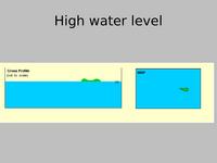
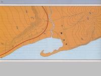
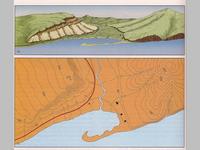
| + | * steepness of slope. | ||
| + | * find steepest, flattest place on map | ||
{{lesson slide||}} | {{lesson slide||}} | ||
| + | [[Image:Members:2012-02-14 23 03 39u-scan.pdf|page=16|right|200px]] | ||
| + | [[Image:Members:2012-02-14 23 03 39u-scan.pdf|page=17|right|200px]] | ||
| + | [[Image:2011 Jorgensen Topography Presentation.pdf|page=7|right|200px]] | ||
| + | [[Image:2011 Jorgensen Topography Presentation.pdf|page=8|right|200px]] | ||
| + | [[Image:2011 Jorgensen Topography Presentation.pdf|page=9|right|200px]] | ||
| + | [[Image:2011 Jorgensen Topography Presentation.pdf|page=10|right|200px]] | ||
| + | [[Image:2011 Jorgensen Topography Presentation.pdf|page=11|right|200px]] | ||
| + | [[Image:2011 Jorgensen Topography Presentation.pdf|page=13|right|200px]] | ||
| + | [[Image:2011 Jorgensen Topography Presentation.pdf|page=14|right|200px]] | ||
| + | [[Image:Members:Basic SAR overhead 490.pdf|right|200px]] | ||
| + | [[Image:Members:2012-02-18 19 54 12u-scan.pdf|page=2|right|200px]] | ||
| + | [[Image:Members:2012-02-18 19 54 12u-scan.pdf|page=3|right|200px]] | ||
| + | [[Image:2011 Jorgensen Topography Presentation.pdf|page=21|right|200px]] | ||
| + | [[Image:2011 Jorgensen Topography Presentation.pdf|page=22|right|200px]] | ||
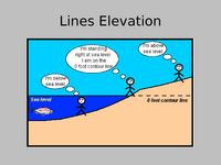
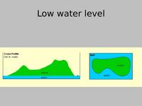
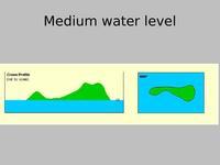
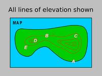
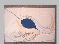
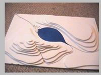
* visualizing land forms | * visualizing land forms | ||
| + | |||
{{lesson slides end}} | {{lesson slides end}} | ||
| Line 72: | Line 92: | ||
* {{link|Members:SAR Fundamentals/Restricted/Ralph Eckman 2013-01}} | * {{link|Members:SAR Fundamentals/Restricted/Ralph Eckman 2013-01}} | ||
* 2011 Jorgensen Topography Presentation {{document format links|2011 Jorgensen Topography Presentation}} | * 2011 Jorgensen Topography Presentation {{document format links|2011 Jorgensen Topography Presentation}} | ||
| + | * {{link|Image:Members:SAR-Fundamentals-Topography.pdf}} | ||
| + | * [[Training/Ideas/Topography]] | ||
== Question bank == | == Question bank == | ||
Current revision
Contents |
[edit] Subject
What is this lesson plan about?
Introduction to using maps for navigation - elevation and land forms.
[edit] Authors
List who wrote this lesson plan.
Brett Wuth
[edit] Scope
What is included in this lesson, what's not and why.
This lesson is an introduction to Navigation for SAR Fundamentals students.
It is part of a larger 8 hour series of lessons.
- SAR Fundamentals Manual: Ch.13 "Navigation"
- Basic SAR Skills Manual: Ch.7 "Navigation"
[edit] Prerequisites
What should students already know/have accomplished before the lesson is presented.
[edit] Objectives
At the conclusion of this lesson the participants:
- will be able to ...
[edit] Time Plan
Total Time: 45 minutes
| Time | Material
|
|
00:00 3 min |
Introduce topic title Introduce Instructor Present Objectives |
|
00:03
|
instructional points in normal font aids, exercises, activities in italic
|
|
|
|
|
|
|
|
|
|
|
|
|
|
|
|
|
|
|
|
|
|
[edit] Aids
What materials are needed or useful in presenting this lesson.
- 82G/8 and 82H/5 for each pair of students
- plenty of table space
- overhead projector
- screen
- slides of topo maps
- Ralph Eckman 2013-01
- 2011 Jorgensen Topography Presentation (download/print: .pdf; edit: .odp)
- Image:Members:SAR-Fundamentals-Topography.pdf
- Training/Ideas/Topography
[edit] Question bank
List of questions suitable for an review/exam of this section.
see Question bank
[edit] Frequently Asked Questions
What are some of the questions that students typically ask. Include the answers.
[edit] Feedback
When has this lesson been presented. What was the feedback.
[edit] License
What can others do with this lesson?
Copyright (c) 2011-2013, Brett Wuth.
This work is licensed under a
Creative Commons Attribution-NonCommercial 2.5 Canada License.
To view a copy of this license, visit
http://creativecommons.org/licenses/by-nc/2.5/ca/
or send a letter to Creative Commons, 559 Nathan Abbott Way, Stanford, California 94305, USA.
[edit] Reference Material
If you need to cite sources, do so here.
[1]
[edit] Notes
Any additional notes, etc.

